The ambitious project of the country, Virtual Singapore, a 3D digital model of the country, will be rolled out next year during July. The project will help the users to develop sophisticated tools and applications for test-bedding concepts and services, planning and decision-making, and research on technologies to solve emerging and complex challenges for Singapore.
The programme is part of Singapore’s Smart Nation drive, and was first announced in 2014. The main team behind the SGD73 million project comprises National Research Foundation (NRF) and Singapore Land Authority (SLA). It has completed the 3D model of the whole island and is currently working on tools like route planners and hazard alert systems.
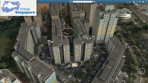
The 3D model of the city will give diverse types of information, such as details regarding amount of direct sunlight a particular housing unit gets to the number of parking spaces right below a housing block.
Virtual Singapore includes semantic 3D modelling, which comprises detailed information such as texture, material representation of geometrical objects; terrain attributes, for example, water bodies, vegetation, transportation infrastructure, etc. Models of buildings encode the geometry as well as the components of a facility, such as walls, floors, and ceilings, down to its fine details, as in the composition of granite, sand and stone in a building material.
Virtual Singapore has been developed based on geometric and image data collected from various public agencies, and has integrated different data sources to describe the city with the necessary dynamic data ontology.
The 2D data and information co-ordinated through existing geospatial and non-geospatial platforms such as OneMap, People Hub, Business Hub etc. has enriched the 3D Singapore City Model. Advanced information and modelling technology has allowed Virtual Singapore to be infused with different sources of static, dynamic and real-time city data and information such as demographics, movement, climate.
The 3D model information regarding the country will be rolled out firstly to the government agencies.
Ng Siau Yong, director of SLA’s geospatial and data division, said, “The geographic data that we have today, such as locations, physical structures, buildings, traffic data, (they) will be shared on the Virtual Singapore for all the public agencies to use, and they will use them for their planning, services, and operations.”
This technology can be used for more ambitious projects including testing of driverless vehicles. Here, companies need not to put the vehicle on an actual road with heavy traffic – a risky situation – but simulate it safely in a virtual environment and test it under various road conditions.
Ng also added that Virtual Singapore can also enhance town planning in a country with very little space to experiment.
He said, “Singapore is a very unique situation. We are a very densely built environment, with (many) high-rise buildings. With Virtual Singapore, the public agencies will be able to make use of more accurate and precise information to plan the city better.”